Disclaimer: This article is for informational purposes only and does not constitute legal advice. Always consult with qualified legal counsel when drafting or executing easement agreements.
In Texas utility projects, mapping mistakes are more than just paperwork problems—they can become six-figure delays. An easement that looks correct on paper but is off by even a few feet in the field can trigger landowner disputes, construction setbacks, and condemnation do-overs.
As utility providers expand across rural, urban, and transitional areas, precision in easement mapping is no longer a luxury—it’s a necessity.
This article outlines the most common utility easement mapping errors, how they create legal and logistical delays, and what Texas providers can do to prevent them before they halt a project.
Why Mapping Accuracy Matters in Easement Projects
Utility easements define the legal and physical space where infrastructure can be built and maintained. The map and legal description must align perfectly—because both are legally binding.
In Texas, these records are used to:
- File easements with the county clerk
- Support eminent domain proceedings
- Guide field crews and contractors
- Resolve landowner disputes
Any mismatch between map and reality becomes a liability—one that often shows up when it’s too late to fix easily.
Top 7 Utility Easement Mapping Mistakes
1. Centerline vs. Edge-Based Descriptions
Many easements are described from a centerline with a defined width (e.g., 30 feet total, 15 feet each side). But if the map uses edge measurements instead—or omits centerline anchors—the result is ambiguity that can confuse contractors or mislead landowners.
2. Misaligned Survey Plats
Plats attached to easements must match the metes and bounds legal description. Even slight discrepancies (e.g., wrong bearings, scale issues, coordinate shifts) can invalidate the easement or lead to re-survey demands mid-project.
3. Unrecorded Revisions
Utilities often adjust routes after preliminary surveys. But if the recorded easement isn’t updated accordingly, field crews may build on unauthorized ground—risking trespass claims.
4. Inconsistent Use of Datum or Coordinate Systems
Mixing NAD27, NAD83, and local coordinate systems without clear documentation creates positional errors—especially in GIS-integrated workflows or multi-county projects.
5. Missing or Ambiguous Exhibit Labels
Legal filings that reference “Exhibit A” or “easement plat attached” without actual exhibits—or with mismatched labels—create legal uncertainty and delay condemnation processes.
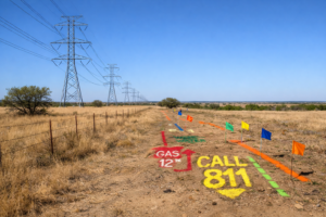
6. Lack of Tie-In to Physical Features
When easements aren’t anchored to recognizable landmarks (fence lines, property corners, road ROW), field implementation becomes guesswork—especially in rural Texas.
7. Failure to Match Title Boundaries
Easements that encroach onto adjacent tracts, fail to stay within a parcel, or don’t reflect title exceptions can trigger re-filings, court challenges, or landowner objections.
How Mapping Mistakes Delay Projects
- Fieldwork Redo: Contractors stop work to wait for corrected plats
- Landowner Pushback: Errors fuel suspicion and resistance
- Legal Delays: Condemnation cases get tossed or reset due to flawed exhibits
- Permitting Conflicts: Agencies reject mismatched plans or unclear alignments
Delays ripple downstream, affecting budgets, public relations, and regulatory compliance.
Preventing Easement Mapping Errors
1. Integrate Survey and Legal Teams Early
Don’t treat mapping as an afterthought. Surveyors and ROW counsel should coordinate during initial alignment planning—not just at the recording stage.
2. Use QA/QC Protocols for Plats
Establish multi-layered reviews before filing: legal, GIS, field ops, and project management. Check for alignment between metes and bounds, plats, and digital maps.
3. Standardize Coordinate Systems and Datum
Pick a single system and stick to it across counties, contractors, and design teams. Document conversions clearly if needed.
4. File Full Exhibit Packages with the County
Never file a legal description without its matching plat. Label exhibits clearly, and double-check that scanned PDFs display all graphics and notations.
5. Conduct Field Recon Before Final Recording
Have crews ground-truth the alignment before the final easement is recorded. Catching issues in the field is cheaper than fixing them post-recording or mid-construction.
Legal Implications in Texas
Texas courts scrutinize easement exhibits in condemnation cases. A flawed or ambiguous map can invalidate a taking or delay possession hearings.
Utilities must also be wary of potential trespass or overreach claims if infrastructure ends up outside the legally defined easement corridor.
Conclusion: The Map Is the Mission
For utility providers in Texas, easement maps aren’t just visual aids—they are legally binding instruments. Every error in a line, label, or coordinate can ripple through permitting, construction, and litigation.
Investing in survey precision, legal oversight, and integrated workflows pays off by preventing costly delays—and by keeping your project aligned on paper, in the field, and in court.