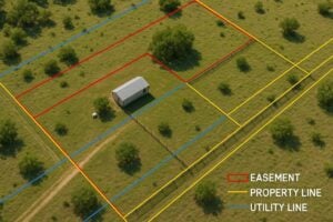
Texas continues to experience unprecedented growth. Expanding communities, industrial developments, renewable energy projects, and transportation improvements all depend on one critical factor: reliable utility infrastructure. Before power lines, water mains, fiber optic networks, natural gas pipelines, or telecommunications systems can be installed, project teams must determine the safest, most efficient path for these essential assets.
That process is known as utility corridor planning.
While it may appear straightforward, corridor planning is one of the most influential stages of any infrastructure project. Decisions made during the planning phase affect permitting timelines, construction costs, environmental impacts, property owner relationships, and long-term system reliability.
When utility corridors are carefully planned from the beginning, projects move through design and construction with fewer surprises. When planning is rushed or incomplete, teams often face expensive redesigns, permitting delays, utility conflicts, and avoidable right-of-way challenges.
For Texas developers, municipalities, utility providers, and engineering firms, investing in comprehensive utility corridor planning can significantly reduce project risk while improving construction efficiency.
What Is Utility Corridor Planning?
A utility corridor is a designated pathway where infrastructure such as:
- Electric transmission lines
- Distribution lines
- Water pipelines
- Wastewater systems
- Natural gas pipelines
- Telecommunications facilities
- Fiber optic cables
- Renewable energy transmission infrastructure
can be installed, maintained, expanded, and repaired throughout their lifecycle.
Utility corridor planning is the process of determining the optimal location for these facilities while balancing engineering, environmental, legal, financial, and operational considerations.
Rather than focusing solely on where infrastructure can be built, corridor planning asks a broader question:
Where should infrastructure be built to minimize risk, maximize efficiency, and support future growth?
Answering that question requires collaboration among surveyors, engineers, GIS specialists, environmental consultants, land professionals, utility owners, government agencies, and property owners.
Why Utility Corridor Planning Matters in Texas
Few states present the same combination of opportunities and challenges as Texas.
Rapid population growth continues to drive demand for:
- New residential communities
- Commercial developments
- Industrial facilities
- Renewable energy projects
- Transportation improvements
- Municipal utility expansions
At the same time, projects must navigate diverse terrain, extensive private land ownership, varying municipal requirements, environmentally sensitive areas, and existing utility infrastructure.
Without early planning, these factors can quickly compound into costly obstacles.
A thoughtfully planned utility corridor helps project teams:
- Reduce environmental impacts
- Minimize utility relocations
- Avoid unnecessary property conflicts
- Improve permitting efficiency
- Support future infrastructure expansion
- Lower long-term maintenance costs
- Improve construction sequencing
Instead of reacting to problems during construction, successful teams identify and resolve potential issues before final designs are completed.
The Risks of Poor Corridor Planning
Every infrastructure project carries risk, but inadequate corridor planning significantly increases the likelihood of delays and budget overruns.
Unanticipated Property Conflicts
Selecting a route without thoroughly understanding property ownership, easements, and existing rights can create unexpected negotiations that delay construction.
Property boundary uncertainties may also require redesigns after engineering work has already begun.
Environmental Constraints
Texas contains wetlands, floodplains, protected habitats, streams, archaeological resources, and other environmentally sensitive areas.
If these constraints are identified too late, agencies may require additional studies or permit revisions that extend project schedules.
Existing Utility Congestion
Many developing areas already contain underground and overhead utilities.
Poor planning can result in:
- Utility relocations
- Design conflicts
- Safety concerns
- Construction delays
- Increased excavation costs
Accurate mapping during the planning phase helps avoid these costly surprises.
Permitting Delays
Permits often require detailed supporting information regarding project alignment, environmental impacts, property ownership, and engineering documentation.
Incomplete corridor planning frequently results in multiple rounds of agency review.
Every revision adds time.
The Utility Corridor Planning Process
Although every project is unique, successful utility corridor planning generally follows several key phases.
1. Project Definition
The planning process begins by defining project objectives.
Questions commonly include:
- What utility is being installed?
- What capacity is required?
- How long is the corridor?
- What communities will be served?
- What future expansion should be considered?
Establishing these goals early helps guide every subsequent decision.
2. Data Collection
Accurate decisions require accurate information.
Planning teams typically gather:
- Existing utility records
- Property ownership information
- Survey data
- Elevation models
- Aerial imagery
- Floodplain mapping
- Environmental databases
- Transportation information
- Municipal planning documents
- Zoning information
This foundational data allows planners to compare potential routes objectively rather than relying on assumptions.
3. Route Evaluation
Rather than identifying a single alignment immediately, experienced planning teams evaluate multiple alternatives.
Each route is assessed according to factors such as:
- Construction feasibility
- Environmental impact
- Property acquisition requirements
- Existing utility conflicts
- Estimated costs
- Maintenance accessibility
- Future expansion opportunities
Evaluating alternatives early often reveals opportunities to reduce costs while improving long-term operational efficiency.
4. Stakeholder Coordination
Infrastructure projects rarely involve only one organization.
Successful corridor planning requires communication among:
- Utility owners
- Engineering firms
- Surveying professionals
- Environmental consultants
- Municipal governments
- County agencies
- State agencies
- Property owners
- Developers
Early collaboration allows concerns to be addressed before they become project delays.
5. Final Corridor Selection
After technical evaluations are complete, planners identify the preferred alignment.
This decision balances:
- Engineering practicality
- Environmental stewardship
- Regulatory compliance
- Cost efficiency
- Long-term operational value
The selected corridor then moves into detailed engineering and permitting.
How Surveys Shape Successful Utility Corridor Projects
Surveying provides the spatial accuracy that utility corridor planning depends upon.
Without reliable survey data, every downstream decision becomes less certain.
Professional survey services establish the framework for engineering design, property evaluation, permitting, and construction planning.
Several survey types contribute to successful corridor development.
Boundary Surveys
Boundary surveys verify property lines and identify ownership limits before design work progresses.
Accurate boundary information helps reduce disputes, supports right-of-way acquisition, and ensures infrastructure is located within the appropriate legal limits.
Topographic Surveys
Topographic surveys document natural and man-made features that influence corridor design, including:
- Elevation changes
- Drainage patterns
- Existing roadways
- Structures
- Trees
- Surface utilities
- Terrain characteristics
These details enable engineers to optimize alignments while minimizing grading, drainage challenges, and construction impacts.
Utility Location Surveys
Understanding existing infrastructure is equally important.
Utility location surveys help identify underground and above-ground facilities, reducing the risk of conflicts during construction and supporting safer design decisions.
Accurate utility mapping also decreases the likelihood of unexpected relocations that can significantly delay project schedules.
The Role of GIS and Geospatial Data
Modern utility corridor planning extends well beyond traditional paper maps.
Geographic Information Systems (GIS) enable project teams to combine multiple layers of spatial information into a single, interactive planning environment.
Instead of reviewing separate maps for property ownership, floodplains, utilities, environmental constraints, transportation networks, and topography, GIS allows planners to visualize how these elements interact across an entire corridor.
This integrated approach improves decision-making throughout the planning process.
For example, GIS analysis can quickly reveal where a proposed alignment intersects environmentally sensitive areas, crosses existing utility infrastructure, or enters parcels with complex ownership patterns. Identifying these issues before engineering begins helps reduce redesigns and shortens the permitting process.
GIS also supports collaboration by providing engineers, surveyors, environmental consultants, and project managers with access to the same accurate spatial data. When everyone works from a common dataset, coordination improves and the risk of conflicting design assumptions is reduced.
For long-term infrastructure owners, GIS continues to deliver value after construction by supporting asset management, maintenance planning, future expansion projects, and emergency response.
Permitting and Regulatory Considerations
One of the most common reasons utility infrastructure projects experience delays is an underestimation of the permitting process. While engineering and construction often receive the most attention, obtaining the necessary approvals can consume a significant portion of a project’s timeline.
In Texas, permitting requirements vary depending on the type of utility, the location of the project, and the agencies involved. A corridor that crosses multiple jurisdictions or environmentally sensitive areas may require approvals from municipal, county, state, and federal entities.
Common permitting considerations include:
- Environmental reviews
- Floodplain development requirements
- Roadway crossing permits
- Railroad crossing agreements
- Drainage approvals
- Utility coordination permits
- Construction access permits
- Stormwater compliance requirements
Beginning the permitting process early allows project teams to identify documentation requirements before final engineering is complete. Survey data, GIS mapping, environmental assessments, and right-of-way documentation all contribute to a smoother review process.
Environmental Planning
Environmental considerations should never be viewed as an afterthought.
Utility corridors may intersect wetlands, streams, protected habitats, flood-prone areas, or culturally significant sites. Identifying these resources during the planning phase gives engineers flexibility to adjust alignments before substantial design investments have been made.
In many cases, relatively minor route adjustments can avoid environmentally sensitive areas altogether, reducing permitting complexity and minimizing mitigation costs.
Transportation Coordination
Many utility corridors parallel or cross highways, county roads, rail corridors, or other transportation infrastructure.
Early coordination with transportation agencies helps project teams understand:
- Access restrictions
- Construction timing requirements
- Traffic control expectations
- Clearance requirements
- Future roadway expansion plans
Planning for these factors early minimizes redesigns later in the project lifecycle.
Stakeholder Coordination and Right-of-Way Planning
Utility corridor planning is as much about people as it is about engineering.
Even the most technically sound alignment can encounter delays if stakeholders are not engaged early and consistently.
Successful projects often involve collaboration among:
- Utility providers
- Engineering consultants
- Surveyors
- GIS specialists
- Environmental professionals
- Developers
- Municipal planners
- County officials
- Regulatory agencies
- Property owners
Each stakeholder brings a unique perspective and set of priorities. Coordinating these interests early helps reduce misunderstandings and keeps projects moving forward.
The Importance of Early Right-of-Way Planning
Right-of-way planning is closely connected to corridor planning.
Once a preferred alignment has been identified, project teams must determine how the necessary land rights will be secured.
Depending on the project, this may involve:
- New easement acquisition
- Easement amendments
- Temporary construction easements
- Fee simple acquisition
- Access agreements
- Existing easement verification
Beginning right-of-way planning during the corridor selection phase helps avoid situations where engineering advances only to discover that critical property rights cannot be obtained as expected.
Building Trust with Property Owners
Private property owners play a vital role in many utility infrastructure projects across Texas.
Clear communication regarding project goals, timelines, access needs, and long-term maintenance responsibilities often leads to more productive discussions and fewer delays.
Providing accurate survey exhibits and clearly defined corridor maps helps property owners understand exactly how a project may affect their land, reducing uncertainty and supporting informed decision-making.
Best Practices for Reducing Construction Delays
While every project presents unique challenges, several proven strategies consistently improve project outcomes.
1. Begin Corridor Planning Early
The earlier planning begins, the more flexibility project teams have to evaluate alternatives and resolve conflicts before engineering is finalized.
Late-stage changes are almost always more expensive than early adjustments.
2. Invest in Accurate Survey Data
Reliable survey information forms the foundation of successful infrastructure planning.
Accurate boundary, topographic, and utility surveys reduce uncertainty throughout design, permitting, acquisition, and construction.
Attempting to save time by relying on outdated or incomplete data often results in significantly higher costs later.
3. Use GIS Throughout the Project Lifecycle
GIS should not be viewed solely as a planning tool.
Maintaining current geospatial information throughout design, construction, and long-term operations creates lasting value by improving coordination, documentation, and future maintenance activities.
4. Evaluate Multiple Route Alternatives
Selecting the first feasible route is rarely the optimal approach.
Comparing several corridor alternatives enables project teams to weigh construction costs, environmental impacts, permitting complexity, property acquisition requirements, and future expansion opportunities before making final decisions.
5. Coordinate Disciplines Early
Surveyors, engineers, GIS specialists, environmental consultants, and land professionals should work collaboratively from the beginning of the project.
Integrated planning helps identify potential conflicts before they become costly field issues.
6. Anticipate Future Growth
Texas communities continue to expand at an impressive pace.
Utility corridors should be planned not only for today’s infrastructure needs but also for future capacity requirements.
Allowing space for future utilities, additional transmission lines, expanded pipelines, or upgraded communications infrastructure can reduce future construction costs and minimize disruption.
7. Maintain Clear Documentation
Accurate documentation supports every phase of a utility corridor project.
Maintaining organized records of survey data, GIS mapping, permits, easement documentation, engineering revisions, and stakeholder communications improves accountability while simplifying future maintenance and expansion efforts.
Why Comprehensive Corridor Planning Delivers Long-Term Value
Although corridor planning represents only one phase of an infrastructure project, its influence extends throughout the entire asset lifecycle.
Thoughtful planning contributes to:
- Faster project delivery
- More predictable budgets
- Improved public safety
- Reduced environmental impacts
- Stronger regulatory compliance
- Better stakeholder relationships
- More efficient maintenance
- Increased infrastructure reliability
Perhaps most importantly, comprehensive planning reduces uncertainty.
Infrastructure projects inevitably encounter challenges, but organizations that invest in quality planning are better positioned to manage those challenges without jeopardizing schedules or budgets.
As Texas continues to invest in transportation, energy, telecommunications, water systems, and community development, utility corridor planning will remain a critical discipline supporting sustainable growth across the state.
Conclusion
Every successful utility infrastructure project begins long before construction equipment arrives on-site. It starts with informed decisions about where infrastructure should be located, how it will interact with existing development, and what challenges may arise over the life of the project.
Utility corridor planning provides the framework for those decisions.
By combining accurate surveying, geospatial analysis, environmental awareness, stakeholder coordination, and proactive right-of-way planning, project teams can identify potential obstacles early, when solutions are typically less costly and easier to implement.
For developers, utility providers, municipalities, and engineering firms working throughout Texas, comprehensive corridor planning is more than a regulatory exercise. It is a strategic investment that supports efficient permitting, minimizes construction disruptions, reduces long-term operational risk, and creates infrastructure that can serve growing communities for decades to come.
Projects built on a strong planning foundation are better equipped to adapt to changing conditions, accommodate future expansion, and deliver lasting value for both infrastructure owners and the communities they serve.
FAQs
What is utility corridor planning?
Utility corridor planning is the process of identifying the most suitable route for utility infrastructure while considering engineering requirements, property ownership, environmental constraints, regulatory compliance, and future growth.
Why is utility corridor planning important in Texas?
Texas experiences rapid residential, commercial, industrial, and energy development. Proper corridor planning helps infrastructure projects avoid delays, reduce costs, simplify permitting, and minimize impacts on property owners and the environment.
What surveys are needed for utility corridor planning?
Projects commonly rely on boundary surveys, topographic surveys, utility location surveys, and other geospatial data to support engineering, permitting, and right-of-way acquisition.
How does GIS improve utility corridor planning?
GIS integrates survey data, aerial imagery, environmental information, property ownership records, and utility locations into a single platform, allowing project teams to evaluate route alternatives more efficiently and identify conflicts early.
How can early planning reduce construction delays?
Early planning allows teams to identify permitting requirements, coordinate with stakeholders, evaluate multiple route options, resolve property issues, and complete necessary surveys before construction begins, reducing the likelihood of costly redesigns and schedule disruptions.